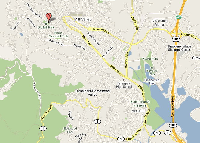
1. How do I get to the starting line?
For
explicit directions, go to www.maps.google.com
and enter 320 Throckmorton Avenue, Mill Valley, CA 94941 as your destination.
**********************************************************************
2. Where do
I stay?
We
recommend the Larkspur Hotel, which is the host hotel of the Quad Dipsea. All
of the hotels and motels listed below are within 15 minutes of the starting
line:
Less
Expensive
Travelodge
Mill Valley, 707 Redwood Hwy., Mill Valley, 415.383.0340
America’s
Best Value Inn, 155 Shoreline Hwy., Mill Valley, 415.332.1732
Tamalpais
Motel, 680 Redwood Highway, Mill Valley, 415.381.4775
Moderate
Larkspur
Hotel, 160 Shoreline Hwy., Mill Valley, 415.332.5700
Best
Western Corte Madera, 1815 Redwood Hwy., Corte Madera, 415.924.1502
Expensive
Mill Valley
Inn, 165 Throckmorton Ave., Mill Valley, 415.389.6608
Mt. Home
Inn, 810 Panoramic Hwy., Mill Valley, 415.381.9000
Acqua
Hotel, 555 Redwood Hwy., Mill Valley, 415.380.0400
Cavallo
Point Hotel, 601 Murray Circle, Fort Baker, Sausalito, 415.339.4700
**********************************************************************
3. How do I
get information on the other Dipsea races?
There are
two other races annually on the Dipsea Trail:
The Dipsea
(7.1 miles) is normally held on the second Sunday in June. It is a handicapped
race (based on age and gender) and is difficult to get into. See www.dipsea.org.
The DSE
Double Dipsea (14.2 miles) is normally held on the fourth Saturday in June. It,
too, is a handicapped event. It is not a problem to get into this race, which
starts at the Stinson Beach end of the trail. See www.doubledipsea.com.
Unlike the
Quad, both of these races are “open” courses, i.e., runners are permitted to
take various shortcuts. This can add to the fun (and also to your chances of
getting lost).
**********************************************************************
4. I don't
know the trail, but would like to train for the race on the course itself. What
do I do?
The best
bet by far is to contact someone who knows the trail and get them to show it to
you. There are a lot of intersections and, while the Dipsea Trail is reasonably
well marked with permanent trail posts, it would be fairly easy to miss a turn.
If you want
to go exploring on your own, you might want purchase a map. You can find them
at The Depot Bookstore at 87 Throckmorton Street in Mill Valley. The best one
is called “A Rambler’s Guide to the Trails of Mt. Tamalpais” by Olmstead Maps.
A less detailed map is also available at www.durt.org/images/dipsea_tpo.jpg,
reproduced here:
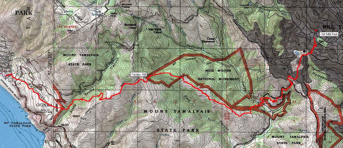
Using a
good map and the following verbal description, you probably won't get too far
lost.
Park on the
city streets nearest the intersection of Throckmorton and Cascade in Mill
Valley (and observe the parking regulations). Starting from the intersection of Throckmorton and Cascade
Drive in Mill Valley:
Proceed
southwest on Cascade Drive. Old Mill Park is on your left. The actual Dipsea
race starts on Throckmorton and Miller Ave. , but the Quadruple and Double
Dipsea races eschew the three blocks of city streets (and the traffic control
required to use them). At the end of the block, Cascade bears to the right, but
go straight up what looks like a driveway. About 50 yards up the hill, you'll
see the bottom of the infamous (there are 671 of them) stairs.
At the top
of the first stretch of stairs, turn right onto the street. At the first
corner, turn sharply left. Look for the next stretch of stairs on your right.
You may occasionally see "Dipsea" stenciled onto the street. All of these markings are accurate.
At the top
of these stairs again turn left and look for the next stairs on the right.
At the top
of these stairs, turn right (uphill) onto the street (Sequoia Valley Rd.). This
is a fairly busy road, be careful. After a long block, bear to the right
(Walsh) into the new sub-division. There is an open metal gate at the entrance
to the sub-division. This used to be the Flying-Y Ranch, but was sub-divided in
1990.
Stay on the
cul-de-sac until the end. Go straight out the back and the trail briefly
becomes dirt. After about 100 yards, it becomes paved again. This is Bay View Drive. Follow it to
the end of the street. (Believe it or not, you've now traveled only 0.92
miles.)
At the
intersection (the cross street is Panoramic Highway), bear toward about one
o'clock and you'll see the trail head across the street.
The city
part now ends and the trail running begins. About 150 yards down the trail
there is a fork. Take the left hand fork (downhill) and follow it to the street
below. This section is known as Windy Gap.
At the
street (Muir Woods Road), cross and look for the trailhead across the street.
Follow this trail for a little more than half a mile. (Note: in the winter of
2006 there was a slide and washout that closed this section of trail. Runners
being runners, many have traversed it anyway. If you go around the “trail
closed” sign, you will find the trail in decent shape except for about a
50-yard stretch where you will likely have to scramble a bit and also cross
over a 30-inch diameter drain pipe. Alternatively, you can simply turn right
and follow the narrow road down the hill for about half a mile. If you take the
road route, look for a bunch of mailboxes on your left and the trail head
immediately west of them to pick up the trail again.)
As you
approach the mailboxes, you'll see the trailhead directly across the dirt road.
Follow the trail down the hill. At the bottom it widens and you make a hairpin
turn to your right. You'll see a
park maintenance building on your right and a road (Muir Woods Road again) straight
ahead.
Cross the
road into the parking lot on the other side. On your right hand side you'll see
a railing and some steps leading down to a creek (Redwood Creek). There is a
water fountain here, this is the only water before you get to Stinson Beach.
The creek may or may not be dry, but there is now a small wooden footbridge
over it. If it has recently rained a lot, the water in the creek may flow over
the wooden bridge. In this instance, there will be a sign showing a detour for
the Dipsea trail. Ignore it.
You'll get your feet wet, but this is the proper trail.
Cross the
creek and follow the trail (obvious) on the other side up the hill through the
redwoods.
After about
a quarter mile of uphill you'll come out to a fire road (Deer Park fire road).
The trail and the fire road criss-cross several times over the next couple of
miles, but run essentially parallel to each other. The race route always
follows the single-track trail. The trail heads are pretty well marked with
permanent markers.
After being
out in the open for a while, you will go back into the deep woods again and
cross the Deer Park fire road one last time, climbing a big hill (known as
Cardiac) to the top, where it comes out into the open again.
At the top
there is an intersection with a fire road (Old Mine Road). Go straight across.
There will be an aid station here during the race (mile 4.07). You also get
your first view of the ocean here (if it’s not foggy).
The next
mile or so follows a section of trail that was refurbished in 2008 and is now a
very smooth and slightly downhill trail that locals are calling the “Freeway.”
The trail
eventually cuts off to the right into some trees. After about 200 yards you'll
see a fence straight ahead, where the trail bends to the right. During the
single Dipsea, you hurdle this fence and go straight down the hill (and I mean
straight down) called Swoop Hollow. The Quadruple sticks to the trail (the park
rangers don't like this short cut) to the right, which is somewhat slower but
very scenic through more redwoods.
After about
a half-mile, the trail turns left and you go down a treacherous stretch of
uneven landings, full of tree roots and often very damp from condensation of
the fog. This is called Steep Ravine. Be careful here; 90% of the people I know
who injure themselves on this trail do so here. At the bottom, there is a wooden bridge. After crossing it,
turn left.
After about
100 yards there is a fire road. During the single Dipsea everyone turns right
and takes some poorly-marked short-cuts which involve considerable running on a
paved road. It's quicker but you'll get lost if you don't know it. The
Quadruple follows the single-track trail which goes straight across the fire
road and up the hill (called Insult Hill).
This brings
you out into an open section called The Moors. From here you can see Stinson
Beach for the first time. The trail crosses a couple of more fire roads, but
just keep your same bearing and stay on the single-track trail.
You drop
back into the woods for the last time and come out to a road (Panoramic
Highway). Cross the road and run down the dirt hypotenuse and you quickly come
to another road (Highway 1).
Turn right
on Highway 1 and cross to the other side at your first opportunity (often lots
of traffic here).
Take the
first left (Arenal Ave.) and follow it for about two blocks. You'll see the
Parkside Café, a small cafe/snack stand on your left. Congratulations, you made
it. The Quad actually takes the
first left from Arenal onto Marine Way and goes to the fence at the end to
avoid causing congestion in front of the café. The single Dipsea goes through
the gate at the end of the street to a finish about 70 yards past it in Stinson
Beach State Park. But there is a water fountain just behind the Parkside Café and
food there. And if you follow Arenal around the corner to the right (around the
little park) you’ll also find a small local grocery store, The Superette.
Either is a good spot to re-fuel if you are going to run back to Mill Valley.
**********************************************************************
Revised
7/21/2010