


Course Description
Updated January 10, 2013
From there, the course stays high on the mountain all the way to Pan Toll (park regs: no crew), dropping down to Cardiac Aid Station (no crew) and then swooping down Deer Park fire road and along Redwood Creek Trail to an aid station near Muir Beach (yes crew).
Switchbacks take runners up Middle Green Gulch, connecting via Coyote to the Miwok Trail into Tennessee Valley Aid Station (yes crew/yes dropbags). From Tennessee Valley, runners ascend Marincello and hop onto Bobcat to the Wolfback Ridge/SCA trail and an aid station at the Conzelman/McCullough intersection (yes crew).
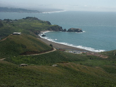
Fly down Coastal fire road and take the flower-filled path up out of Rodeo Valley via Bobcat/Alta/Miwok/Old Springs to Tennessee Valley Aid Station (yes crews/dropbags/pacers).
Roll along Coastal up and over to Pirates’ Cove and the aid station near Muir Beach. Save some energy for the last push along Redwood Creek Trail, UP Deer Park fire road to Cardiac Aid Station then gaze out at the incredible Point Reyes’ seashore vistas on the return while dropping down down up down the single-track and huge stone steps to a hard-earned finish at the Stinson Beach Community Center.
Starting line
- Click here for location of race morning check-in and start (Park at A and walk over to B).
- Funnel directly onto Matt Davis Trail. Don’t trip on anything. There are a couple of sticks and rocks just
looking for your toes on this section. Switchback up through the woods to take a left onto Coastal Trail. Run
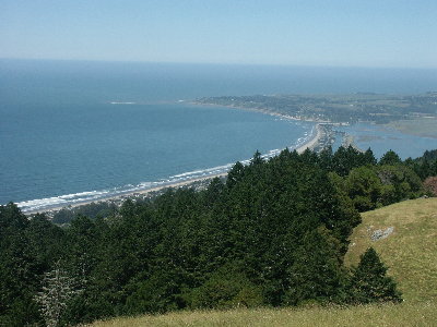
along the flanks of Mount Tamalpais with views of Stinson Beach, Bolinas Lagoon, and the Point Reyes National
Seashore off to your left.
- Rolling fire road through some ancient Redwoods to the Randall Trail gate on your left. Keep your eyes open so
you don’t miss the course markings. Go left down Randall Trail (fire road) to aid station.
Randall Trail Aid Station
- Eat, drink, use the Port-a-Potty, access your drop bag, then turn around and retrace your route back up Randall
and right onto the Bolinas Ridge fire road to BoRidge aid station!
Bolinas Ridge Aid Station
- Say thanks to the Tamalpa Running Club volunteers again, head back
along Coastal Trail all the way through Pan Toll Ranger Station (NO crews allowed here – Park Service regulations)
and along Old Mine Trail to the new Cardiac aid station.
Cardiac Aid Station
- You’ve got a long downhill coming up so use the Port-a-Potties here and then drop down Deer Park fire road and
carefully cross Muir Woods Road to get onto Redwood Creek Trail, coming out onto the shoulder of the road for
about half a mile near the Pelican Inn – single-file only, please. Take a quick left onto the fire road and run
all the way to the Muir Beach parking lot.
Muir Beach Aid Station
- This aid station will be in the Muir Beach parking lot - outbound, you'll then retrace your steps to the lovely,
recently–renovated Middle Green Gulch trail to get up to the ridge, go left onto Coyote at the top, then turn
right onto Miwok to Tennessee Valley aid station. Inbound, you'll be coming from Pirates' Cove to the aid station,
then staying on the fire road over to the Pelican Inn and Redwood Creek Trail.
MUIR BEACH BACKTRACK (outbound) – to add a little spice to the fact that you MUST run all the way to the Muir Beach
Aid Station in the parking lot, then retrace your steps a half-mile to the Middle Green Gulch gate (outbound only),
bib numbers will be recorded in order at the Muir Beach Aid Station. At the finish, I will draw two random numbers
and the two runners who checked into MB in those slots will receive a free, guaranteed entry into the 2014 Miwok 100K.
For example, if you are the 147th runner to check in at Muir Beach and I draw 147 – a free 2014 entry is yours!
Tennessee Valley Aid Station
- Head out of the aid station as directed and turn left onto Marincello fire road, left on Bobcat, left onto
the SCA trail – yep, that’s the the Golden Gate Bridge just below you - cross McCullough near Conzelman and,
look, there's the aid station.
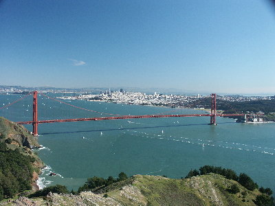
Bridge View (Rodeo Valley) Aid Station
- Surf's up at this AS run by Coastside Running Club from
Half Moon Bay. Enjoy their incredible energy and inspiration then get
outta there! Cruise down Coastal Fire Road all the way to paved Bunker Road.
Cross the road carefully, turn left and run on the shoulder of the road for about 250 yards,
turn right and go across a wide bridge onto Rodeo Valley Trail, turn onto Bobcat, and take Bobcat uphill to Alta,
Miwok, Old Springs to Tennessee Valley aid station.
Tennessee Valley Aid Station
- Say "Hi" to Stan and his great crew, then cruise left out of the parking lot down to Coastal fire road and the
exquisite Pirates' Cove route. Up, over, around and down to aid station at or near Muir Beach.
Muir Beach Aid Station
- Firm cutoff here due to park regulations. Whatever else happens, you have to leave MB by 7:00 p.m. Along Hwy 1
shoulder (single-file, eh?) to Redwood Creek Trail. Cross Muir Woods Road and head up Deer Park fire road, left
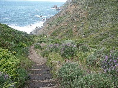
at Cardiac onto Dipsea trail and its monster stone steps. One last push up Insult Hill, swoop down the Moors,
and into the woods. Go straight across at Panoramic Highway (carefully), run about 100 yards of dirt, then take
a hard right onto the road, another hard right at the Fire Station, and you’ll see us waiting at the finish line for you!